INFOMAR reports successful start of the survey season
F. Sacchetti, T. Furey, MI
Since the beginning of April, the INFOMAR team has been extremely busy with survey activities and data acquisition.
Survey operations, carried out onboard the R.V Celtic Voyager commenced off the Cork coast between Ballycotton and Youghal, shoreward of the coverage attained in previous years.
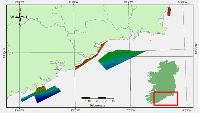
Extent of multibeam coverage achieved during the survey
The area forms part of the INFOMAR South Priority Area (SPA), stretching from Mizen Head in the southwest to Carnsore Point in the northeast. Survey operations alternated between the inshore area and an offshore block south of Waterford (Figure 1). The priority Bays of Youghal and Dungarvan were partially surveyed with dramatic seabed morphology imaged.
An area east of Wexford and west of the Blackwater Bank was also mapped during a period of strong westerly winds. This displayed a seabed largely created by sediment waves. Survey operations moved west during the final week of survey to an area that included the Old Head of Kinsale and Courtmacsherry Bay.
A total of 19 wrecks, some of which were previously uncharted, were mapped during this survey. Figure 3 (lower left corner) shows an image of a wreck off the Waterford coast
Additionally, a total of 111 sediment samples were collected using a Shipek grab. The acoustic backscatter derived from the multibeam echosounder can provide indirect information about the sediment type; however only sediment sampling and grain-size analysis can provide direct observations.
The correlation between the mean grain size and the acoustic backscatter classification will ultimately be transformed into maps of seafloor sediment properties.
Value-added programme
INFOMAR supported a significant EC event hosted by Marine Institute in Galway on in May entitled Atlantic – A Shared Resource, as part of Ireland’s presidency. It was attended by An Taoiseach Enda Kenny; Minister Simon Coveney, and EU Commissioners Maria Damanaki and Maire Geogeghan-Quinn, as well as senior officials and leading ocean scientists from Canada, USA, and Europe.
The outcome was the signing of the Galway Statement on Atlantic Ocean Cooperation, and recognition of Ireland’s leading role in seabed mapping, which is critical to underpin oceanographic and ecosystem modelling, infrastructural development, and sustainable resource management.
The value of seabed mapping has been acknowledged to the extent that scientific experts across Europe, Canada and the USA have identified mapping the North Atlantic as a crucial target by2020.
Biodiversity, technology & outreach
At a more local level, numerous meetings and discussions are ongoing with stakeholders, academia and researchers to extend the reach and use of INFOMAR’s valuable data, infrastructure and knowledge holding.
Canadian-Irish research opportunities are currently being investigated in the area of technology application and development for seaweed resource assessment. Collaborative opportunities in developing outreach and education products are ongoing, and INFOMAR data product development is being investigated to derive user focussed outputs.
Clare coast survey coverage extension
During the first week of June, an additional area west of Co Clare was surveyed extending the overall 2013 coverage to 800 km2. Due to an abundant wave climate resource, favourable seabed morphology and proximal port facilities, this area has been identified by Sustainable Energy Authority Ireland (SEAI) as a suitable region for future deployment of wave energy converters.