INFOMAR survey operations 2012
Eoin MacCraith, GSI
The 2012 survey season comprised a mixture of collaborative work and progress for the national mapping project. With four survey vessels at work by the end of the season on behalf of the Geological Survey of Ireland (GSI) and the Marine Institute (MI), bathymetric and geophysical coverage of the seafloor was significantly extended in a number of locations around the Irish coast.
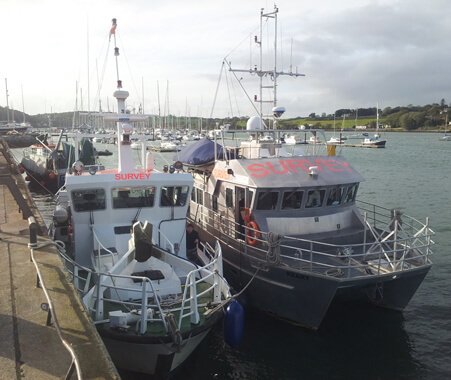
RV Cosantóir Bradán and RV Keary alongside in Crosshaven. Note the tow-mount for the multibeam sonar on on the Cosantóir Bradán which is in the raised position
Dundalk Bay was the first area to be surveyed at the start of the season as a continuation of the INISHydro INTERREG IVA project that had begun last year. INISHydro is a 3-year programme with the Maritime and Coastguard Agency (MCA) in the UK as lead partners.
The project brings together 7 partners: MCA, Geological Survey of Ireland (GSI); Marine Institute (MI); the Agri-Food and Biosciences Institute (AFBI); the Scottish Association of Marine Science (SAMS); the Northern Lighthouse Board (NLB) and the United Kingdom Hydrographic Office (UKHO) to conduct hydrographic surveys in Ireland, Northern Ireland and Scotland.
The GSI inshore survey vessels RV Keary and RV Geo were based in Port Oriel, Co Louth from April to May. Each vessel was tasked to survey specific areas according to water depth: RV Geo, a 7.5m RIB, mapped from the 5m contour inwards, while RV Keary, a 15m catamaran, focussed on the seabed between 5m and 10m depth.
Data gathering
The survey work produced a combined bathymetric dataset from three vessels covering the outer approaches to Dundalk; the shoals around Dunany Point in the south and the offshore extents of the bay. An ADCP (Acoustic Doppler Current Profiler) was deployed from RV Keary in Dundalk Bay to record the speed and direction of currents in a specific location. In March, RV Celtic Voyager carried out survey work off the Co Clare coast on behalf of the Sustainable Energy Authority of Ireland (SEAI).
The second survey leg, from mid May to early June, involved mapping 873 square kilometres of seabed in the ‘East Priority Area’ in the Irish Sea. Eleven wrecks were mapped during that leg. Following mapping operations in Dundalk Bay in mid-June, RV Keary transited south to the next survey area off the coast of Bunmahon, Co. Waterford. Survey work was carried out in support of the INTERREG-funded Atlanterra Project, which has designated the Bunmahon area as a Geo-park.
During this work, RV Keary was based in Dunmore East from where the vessel could transit to the survey area. Two uncharted shoals were mapped during this survey and the information was delivered in the form of H-notes to the UKHO who subsequently issue a ‘Notice to Mariners’ alerting them to these hazards. The shoals will now feature in new editions of the relevant charts.
Following the survey off Bunmahon, RV Keary transited to Galway to participate in the Volvo Ocean Race festival. The crew welcomed the public on board for tours of the vessel and also put to sea as part of a spectator flotilla during the in-port race of the Volvo fleet.
West coast surveying
The next survey leg took place around Inishbofin, Inishturk and Killary harbour in July and August. RV Keary and RV Geo were based in Inishbofin harbour throughout the survey, refuelling periodically in Cleggan on the mainland. Initially, two specific sites were mapped for BIM who were investigating the potential of locating deep-water aquaculture sites in the area. A larger area around the islands was also mapped to provide bathymetric data for oceanographic current modelling to be carried out by the Marine Institute, along with extending INFOMAR national mapping coverage around the islands and their many reefs and shoals.
The survey data revealed very interesting underwater topography, containing extensive rocky outcrop, fault lines and sedimentary features. The onshore geology of the islands is structurally complex and some of it can now be traced offshore using the bathymetric data. Northbound Once operations around Inishbofin were complete in early August, RV Keary transited north to Killybegs, Co Donegal, where she refuelled and underwent maintenance on her crane, before proceeding up the coast to Burtonport. RV Geo was transported there over land.
As opposed to a conventional INFOMAR survey leg, this was a job involving collaborative work between the GSI and the Underwater Archaeology Unit of the Department of Heritage, Arts and Gaeltacht. RV Keary was tasked as a diving platform for marine archaeologists carrying out an excavation on a potential Spanish Armada shipwreck off Rutland Island, while RV Geo conducted shallow-water mapping between Burtonport and Arranmore Island as part of the national mapping programme.
This inter-departmental collaboration had also been carried out during the 2011 survey season and once again RV Keary proved to be a versatile platform. RV Geo extended the bathymetric coverage collected the previous year. From July to August, RV Celtic Voyager carried out further surveying in the East Priority Area, mapping ten wrecks in the process and 864 square kilometres of seabed.
Following this work she carried out survey operations in Galway Bay and the Celtic Sea, from late August to late September. New arrival The final survey leg of 2012 took place in Cork harbour, beginning in early September and was the first outing for the latest addition to the INFOMAR survey fleet, MV Cosantóir Bradán. As a fisheries patrol vessel in its previous life, the craft was modified by the INFOMAR team to include a bow-mounted multi-beam sonar which has increased INFOMAR’s inshore mapping capability as RV Keary and MV Cosantóir Bradán can now work together to survey a greater area in a given timeframe.
Operating out of Crosshaven the two vessels mapped the channels in Cork Harbour with RV Geo concentrating on the shoals and river banks. The larger vessels finished operations in mid-October while RV Geo continued its campaign of shallow water mapping into early November. With the 2012 surveying season now over, the vessels are now based in Dún Laoghaire for winter maintenance before embarking on the 2013 survey season.