Surveying the white ribbon
Eoin McGrath, GSI
With the bulk of Ireland’s deep, offshore waters now mapped in great detail during the course of the Irish National Seabed Survey, the task of surveying the inshore territory has fallen to the INFOMAR programme (Integrated Mapping for the Sustainable Development of Ireland’s Marine Resource) – a joint venture run by the Geological Survey of Ireland and the Marine Institute.
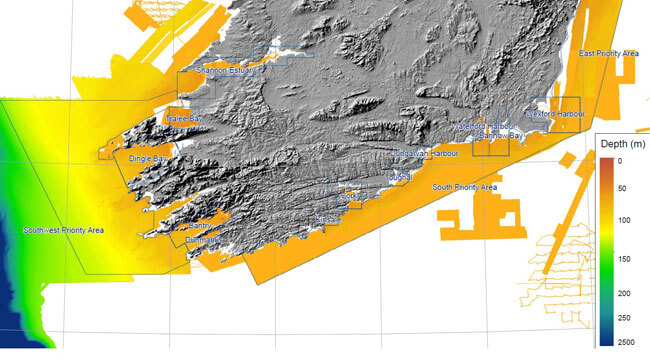
White ribbon of seabed around the Irish coast yet to be surveyed by INFOMAR
Ireland’s rugged coastline makes for a challenging environment for the fleet of small vessels employed to carry out this duty: RV Keary, M.V. Cosantóir Bradán and RV Geo. These boats are required to venture where other vessels do not – areas of dangerous shoals and shallow rocks many of which have not been charted in over a hundred years. These areas to be mapped can be collectively termed as the ‘white ribbon’, ― the blank strip skirting Ireland’s coastline in the image of modern seabed data coverage.
The white ribbon
Surveying these areas is not as simple as arriving in a vessel and following a straightforward grid pattern, scanning the seabed with a sonar device. There are many things to take into consideration when carrying out inshore surveying of a given bay or stretch of coastline.
Firstly, a team must arrive on site in advance of the survey vessel and set up what is known as geodetic control on land. This involves surveying a single point in the ground to a high degree of accuracy, using a GPS device on a tripod.
Once the coordinates are ascertained, a GPS station is set up over it for the duration of the survey; this serves as a control station for the position data collected by the survey vessel, which is vital to accurately position the recorded soundings on the seabed.
Mobilising these base stations is itself a challenge. A secure location is needed, with a clear view of the sky so that the station can receive data from enough satellites. Along with this a reliable power source is required. These criteria narrow down the number of available locations very quickly, especially in rural areas. More often than not, the roof of a Garda station is the most reliable location.
GPS base station
A tide gauge is also required for a survey area , and is usually installed on harbour wall, to measure the rise and fall of the tide over the duration of a survey leg, and sometimes longer.
This dataset is required in order to determine the value of Lowest Astronomical Tide (LAT) at a given location. LAT is the lowest level of the tide that can be predicted to occur during average meteorological conditions or any combination of astronomical conditions. It is the level to which the mapped seabed is ultimately referenced to in the final charts, using a computer model.
Physically measuring the tide at the survey site helps the INFOMAR team to verify this model. Once the base station and the tide gauge are in place, the survey vessels are cleared to commence operations.
The shape and size of a bay determines the pattern in which the vessels must work. Ireland’s coastline is a complex set of inlets and irregular margins. As the vessels’ collective task is to map as far inshore as possible, even over intertidal areas, they must dive in and out of these nooks and crannies, abandoning any possibility of straight survey lines as they approach the coast.
This is a hazardous task – many of these areas were last mapped with lead lines over a hundred years ago; uncharted, treacherous shoals often went undetected by this technique. Even with the most sophisticated modern sensors, the survey crews can be caught out by these shallow rocks unless they stay vigilant at all times.
Mapping close to Inish Turk
In addition to navigational challenges, the vessels must contend with a reduction in survey coverage as the water gets shallower. Due to the nature in which the sonar equipment works, its footprint on the seabed shrinks as the vertical distance between it and the seafloor gets shorter.
This means that the vessels must steer with tighter line spacing as they approach the shore. The result is that the mapping effort increases substantially, with a corresponding reduction in the gains.
The smallest vessel, R.V. Geo, must work on the rising tide while entering intertidal areas. To do otherwise would be to risk running aground. Modern survey equipment is constantly being developed and improved. In 2013, R.V. Keary was equipped with the most state-of-the-art multi beam sonar available, which has increased data quality and hugely cut down on the subsequent processing workload.
As the technology improves over time, the task of mapping Ireland’s complex coastline will become easier and faster; however, the crew must never overly-rely on this technology for keeping the vessels safe. Keeping their eyes peeled will always be an essential requirement!