Independent study says Ireland’s mapping project is value for money
According to Gareth Hetherington of Pricewaterhouse Coopers who carried out an options appraisal report into the INFOMAR mapping programme, their analysis over a 20-year period of the current value of benefits is estimated at €440m.
“This in ratio to cost is approx 4/5:1 so the return on the capital employed is quite good. We’re looking at industry as an exercise or project that can help generate economic activity in light of the recession. [These] are basically the types of projects which all governments say they want to fund,” he emphasised.
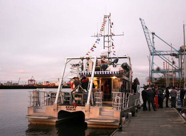
RV Keary was officially named by Barbara Keary, wife of the late Ray Keary, at the Poolbeg Marina in the heart of Dublin. Photo Gillian Mills/Inshore Ireland
“If the private sector was left to undertake the seabed mapping study, the cost associated [to deliver] a project of this nature would be so disproportionate to the financial benefits it wouldn’t be worth their while.”
Gareth Hetherington was speaking at the ten-year celebration seminar of the Irish National Seabed Survey (INSS) and INFOMAR.
Integrated Mapping for the Sustainable Development of Ireland’s Marine Resource is Ireland’s national marine mapping programme and successor to INSS (1999-2005) and is a joint venture of the Geological Survey of Ireland (GSI) and the Marine Institute (MI).
Background
The scope of the INSS (€27m allocation) was to map the entire Zone III (water depths 200m to 4000m) and as much of Zone II (water depths 50m to 200m) as possible.
The focus of INFOMAR is to create a range of integrated mapping products of the physical, chemical and biological features of the seabed in the near-shore, or Zone 1 (0m to 50m) area and remaining Zone II area, thus completing the mapping programme of all of Ireland’s off-shore waters.
Against this background and to fulfil the ‘NDP Value for Money Reporting Requirements for Large Capital Projects (>€30 million), PricewaterhouseCoopers (PwC) were commissioned by the Department of Communications, Energy and National Resources (DCENR) to undertake a detailed appraisal of the INFOMAR project.
According to Hetherington, whilst INFOMAR has a very broad scope in terms of the information it is trying to capture, “if the private sector was left to do it, their scope would be very narrow. As a result, there would be major gaps in the information collated – and that’s assuming the information would be shared. So, this is major rationale for the government to step in.”
Hetherington explained that the study also underpinned the need to develop policy:
“One of the central tenets of having good policy is having very good baseline information on which to base that policy. The study provides information in terms of identifying what opportunities are out there; how to prioritise those opportunities and how to develop policy around managing this very significant resource.”
Influencing policy
As well as developing opportunities internally it can also be used to develop external policy, such as influencing EU fisheries policy:
“So if Ireland can go with an evidence base around fishing quotas or habitats information, then that is a very robust evidence base on which you can help influence policies that impact on Ireland.”
Hetherington also noted the range of legislative and marine conventions that Ireland has signed up to and to which has obligations, such as the Water Framework Directive.
“Under the EU Habitats Directive, States are required to identify and designate SACs. This can only be done with information that this exercise can help deliver,” he said.
Regarding benefits, Hetherington said that the “vast majority” were commercial in nature.
Positive benefit
Focussing on the fishing industry he said that whilst habitat mapping would allow fishermen target areas, it would also provide information on areas to avoid, such as spawning/breeding grounds.
“This would have a major benefit in terms of stock sustainability,” he stressed.
Secondly, he identified the reduced time at sea, and detection of coral.
“You can’t exactly put a financial/economic value [on this] but in terms of destroying coral and stock sustainability then there are major environmental benefits. Based on the size of industry we estimate a potential 2% increase (€14m per annum) in the activity of the sector could be achieved.”
Hetherington added that if an industry is in decline, such as fishing, and you can provide information that halts that decline and keeps it at a steady state, “then it’s quite legitimate to incorporate that as an economic benefit in terms of where you could be and where you actually are.”
Turning to aquaculture he said seabed mapping could help identify key areas where it could flourish, and could also influence licensing.
“Again our research shows that a lack of information is a constraint to licences being issued – and to growth. The growth potential could be estimated at 4%, resulting in economic benefits of €5m per annum.”
Functional foods
Development of the seaweed sector is also identified as another commercial benefit.
“The information provided would allow for significant increase in the use of commercially exploitable seaweed and with developing that whole sector, such as health, snack food products and body care. A 10% increase would be worth about €1m per annum to the sector,” he said.
Turning to offshore renewable energy, Hetherington said the sector was a key area for economic development for Ireland in the 21st century.
“Some of the research we saw indicates that the sector could grow by a factor of 20 over the next 20-30 years. In terms of the bathymetry and sediment information required, this would be provided by INSS/ INFOMAR – and that’s important in two aspects: finding the best location to generate the most energy and which will have minimal impact on the environment.
He added that just a 20% impact on the value of this sector from firm figures in 2002 would bring about €3.6m of benefit per annum to the Irish economy.
On the knowledge economy, Hetherington said Ireland was “technologically advanced” and was a leading light on the world stage.
As for the unknown, he said that with this “massive [free to end user] dataset” we can only start to begin to understand how we’re going to use this information.
“Inevitably if organisations are innovative they will take this information and use it for purposes we don’t know yet, such as identifying niche markets.”
A VITAL INVESTMENT FOR IRELAND’S ECONOMIC FUTURE
John Joyce, Marine Institute
“It is good to see, for a change, a Government agency being praised for sensibly investing public money instead of wasting it,” remarked Senator Ronán Mullen on October 21.
He was speaking to a motion by Senator Cecilia Keaveney that Seanad Éireann “commends the Government’s continued support of the national marine mapping programme INFOMAR and that it “supports the policy of carrying out this vital infrastructural work which is underpinning key and economically significant offshore development in renewable energy, environmental protection, detection of our shipwreck heritage, improvement of fishing efficiency and safety of maritime transport.”
That such a motion should be proposed at Seanad Éireann and be supported in the current climate of recession is perhaps the highest tribute to the work on INFOMAR and the Irish National Seabed Survey (INSS) by the GSI and the Marine Institute over the last ten years.
Independent backing
The decision to continue the project was backed up by the findings of an independent economic study undertaken by Price Waterhouse Coopers which itemised the full economic benefits from INFOMAR to commercial sectors, including fishing, aquaculture, biodiversity, renewable energy, energy exploration and the aggregate industry, as well as to research and in terms of savings on non-compliance fines regarding EU regulations.
“Investment in innovation, research and development is fundamental to Ireland’s efforts to address the economic crisis we face now and, more importantly, to generate high quality jobs and provide employment for a new generation of graduates,” continued Senator Mullen during the debate.
“When I was in secondary school, I was told that Ireland had no natural resources. The INFOMAR project kills that myth once and for all.”
Strategic collaborations
Speaking at the Seabed 10 conference earlier that month, Marine Institute CEO Dr Peter Heffernan looked to the potential development of Ireland’s marine resources through strategic collaborations between industry and science based on information from INFOMAR and the INSS.
Examples he gave included organic and sustainable food production from aquaculture and fisheries, the development of ‘functional foods’ including health giving ingredients sourced from marine animals and plants and the development of new medical treatments using ‘bioactive’ compounds from deep sea animals.
He also predicted enormous strides in the generation of electricity from wave power and the further development of SMART technology to monitor the marine environment – all underpinned by an enlightened attitude to sustainable marine development as part of government policy.
A full transcript of the Seanad Éireann debate can be found at: http://debates.oireachtas.ie/DDebate.aspx?F=SEN20091021.xml&Node=H5
NORWEGIAN COMPANY BEHIND 3D SEABED MAPPING IMAGERY
Peter Bennett
Kongsberg Maritime is proud to have supplied the RV Keary with the multibeam and single beam acoustic echo sounder systems utilised to gather the seabed mapping imagery being collected as part of the Informar project.
The vessel is fitted with a dual head EM3002D multibeam system which provides full coverage and 3D imagery of the seabed along with backscatter reflectivity information to assist in seabed classification. The system is electronically stabilised to ensure the vessel can continue to gather the highest quality hydrographic data over a wide range of weather and sea state conditions, maximising the productivity of the vessel and minimising the survey costs.
The seabed bathymetry, imagery and reflectivity are all available and utilised from the production of navigational charts for the safe navigation of vessels through to the monitoring of environmental habitat and change of habitat for marine environmental conservation and protection.
The EM3002D multibeam system is one of a range of acoustic systems provided by Kongsberg Maritime the range goes from the high frequency shallow water systems to the lower frequency full ocean depth systems.