
INFOMAR 2021 seabed mapping activities
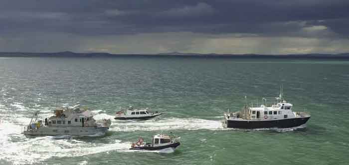
INFOMAR will undertake hydrographic and geophysical seabed mapping activities in the Celtic Sea and Atlantic Ocean between April and October 2021.
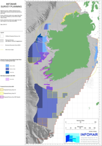
2021 offshore survey areas
The INFOMAR Programme (Integrated Mapping for the Sustainable Development of Irelands Marine Resource), is a jointly managed seabed mapping initiative between the Geological Survey Irelandhttps://www.gsi.ie and the Marine Institute, funded by Department of Environment, Climate and Communications.
Covering some 125,000 square kilometers of underwater territory, INFOMAR will produce integrated mapping products covering the physical, chemical, and biological features of the seabed.
Location and dates of planned operations
April-October (Celtic Sea, Atlantaic Ocean & southwest coast): RVs Keary, Geo, Lir, Galtee, Mallet (GSI)
May 6-June 4 (Celtic Sea): RV Celtic Voyager (MI)
July 7-29 (Celtic Sea): RV Celtic Voyager (MI)
July 30-August 4 (Donegal coast): RV Celtic Voyager (MI)
Sept 1-29 (Celtic Sea): RV Celtic Voyager (MI)
Sept 21-Oct 6 (Celtic Sea): RV Celtic Explorer (MI)
The Marine Institute will operate the following two vessels R.V. Celtic Voyager (call sign EIQN) and RV Celtic Explorer (call sign EIGB).
These vessels will display appropriate lights and markers. They will be listening on channel 16 throughout the course of the survey. The vessels will be towing a magnetometer sensor with a single cable of up to 200 metres in length and a Moving Vessel Profiler cable of variable length up to a maximum of 200 metres.
GSI will operate five vessels: RV Keary (call sign EI-GO-9), RV Geo (call sign EI-DK-6); RV Mallet (call sign EI-SN-9); RV Lir (call sign EI-HI-2) and RV Galtee (call sign EI-2F-G). The vessels will display appropriate lights and markers. The vessels will be listening on channel 16 throughout the course of the survey.
Survey area
RVs Celtic Voyager, Keary, Geo, Mallet, Galtee, Lir are expected to carry out survey operations in the northwest Celtic Sea, Atlantic Ocean and the southwest coast stretching from Roaringwater Bay, Co Cork to Kilkee, Co Clare. Three offshore areas have been selected: two south of Mizen Head and another in the Atlantic Ocean, between Kerry Head and the Aran Islands.
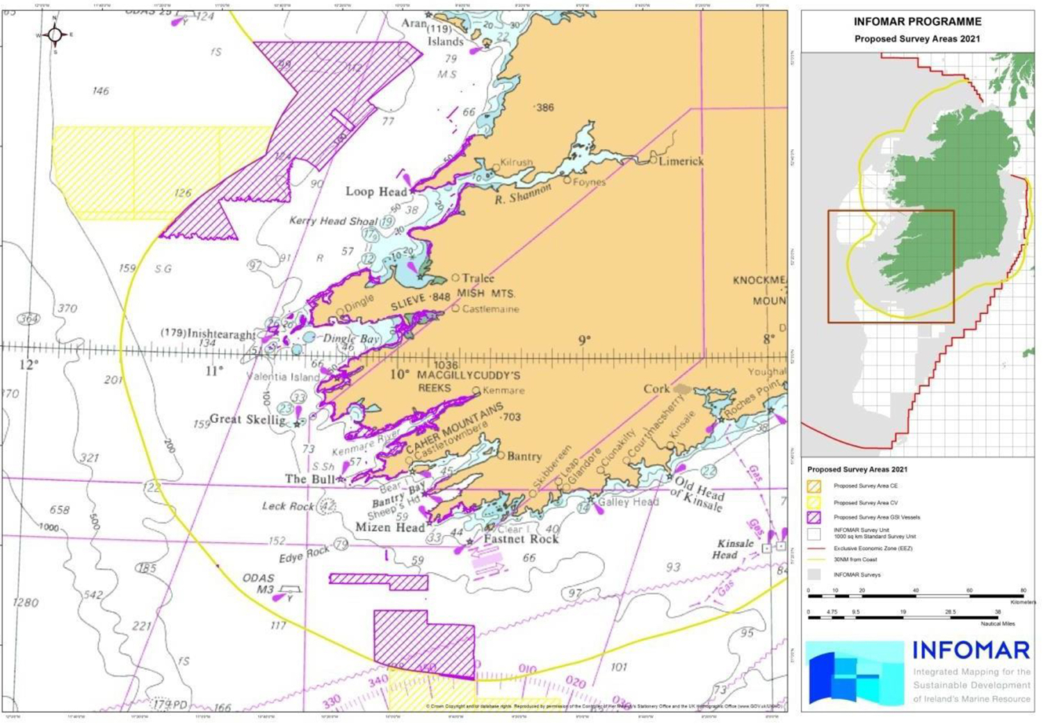 Fig 1: RVs Voyager, Keary, Geo, Mallet, Galtee, Lir – Celtic Sea survey areas
The two sites south of Mizen Head are denoted by the purple coloured hatched areas. The coordinates are:
| Latitude | Longitude |
| 51° 16.625’N | 009° 49.463’W |
| 50° 55.624’N | 009° 34.263’W |
| 51° 16.315’N | 010° 20.588’W |
| 50° 58.923’N | 010° 06.151’W |
The inshore section is denoted in the purple-coloured hatched areas. The coordinates are:
| Latitude | Longitude |
| 51° 38.229’N | 008° 41.806’W |
| 52° 44.936’N | 009° 35.475’W |
The offshore section in the Atlantic Ocean is denoted in yellow and purple hatching in Fig1. The coordinates are as follows:
| Latitude | Longitude |
| 53° 03.404’N | 009° 58.144’W |
| 52° 22.755’N | 010° 52.510’W |
| 52° 44.431’N | 011° 53.757’W |
| 52° 25.858’N | 011° 44.602’W |
Detailed coordinates of each survey polygon can be provided on request.
RV Celtic Voyager is expected to carry out survey operations in the Celtic Sea within the yellow hatched area marked below.
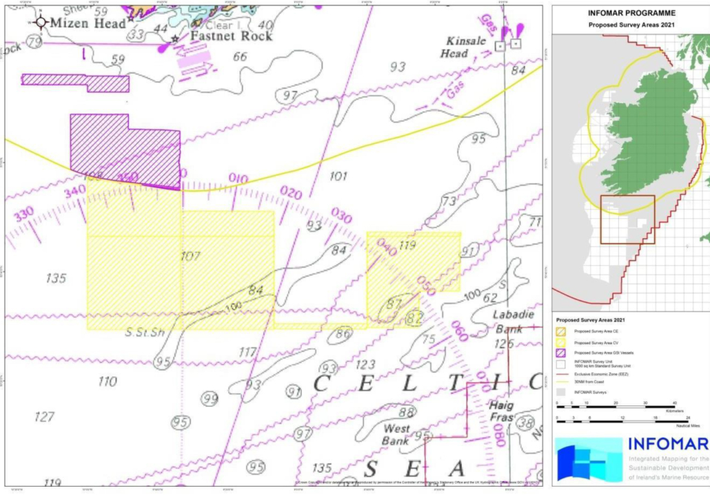
RV Celtic Voyager: Celtic Sea north survey area
The generic coordinates where the survey operations are expected to take place are as follows:
| Latitude | Longitude |
| 50° 30.073’N | 008° 25.221’W |
| 50° 29.648’N | 010° 00.598’W |
| 50° 57.657’N | 010° 01.203’W |
| 50° 47.658’N | 008° 13.366’W |
Detailed coordinates of each survey polygon can be provided on request.
RV Celtic Voyager is also expected to carry out survey operations in the Celtic Sea within the yellow hatched area marked below.
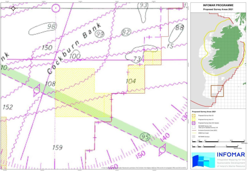
RV Celtic Voyager: Celtic Sea south survey area
The generic coordinates where the survey operations are expected to take place are as follows:
| Latitude | Longitude |
| 49° 21.792’N | 009° 03.012’W |
| 49° 21.564’N | 009° 32.987’W |
| 49° 38.532’N | 009° 33.178’W |
| 49° 44.844’N | 008° 35.920’W |
Detailed coordinates of each survey polygon can be provided on request.
RV Celtic Voyager is also expected to carry out survey operations off the Donegal coast within the yellow hatched area marked below.
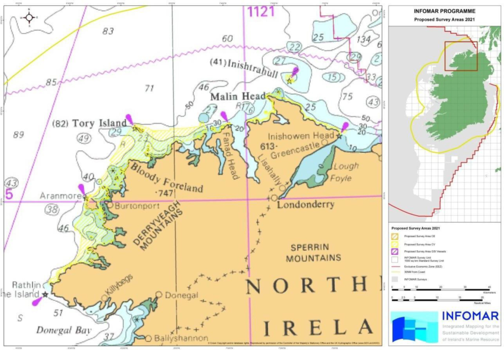
RV Celtic Voyager: Donegal coast survey area
The generic coordinates where the survey operations are expected to take place are as follows.
| Latitude | Longitude |
| 54° 41.664’N | 008° 48.624’W |
| 55° 16.996’N | 008° 15.710’W |
| 55° 13.582’N | 006° 55.701’W |
RV Celtic Explorer is expected to carry out survey operations in the Celtic Sea within the orange hatched area marked below
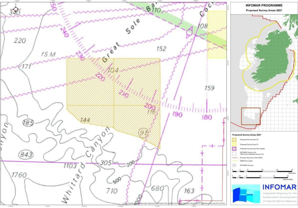
RV Celtic Explorer: Celtic Sea survey area
Detailed coordinates of each survey polygon can be provided on request.
The generic coordinates where the survey operations are expected to take place are as follows.
| Latitude | Longitude |
| 48° 48.655’N | 009° 58.758’W |
| 49° 02.200’N | 010° 50.680’W |
| 49° 20.726’N | 010° 51.371’W |
| 49° 21.365’N | 009° 59.511’W |
Detailed coordinates of each survey polygon can be provided on request.
All mariners are reminded of their responsibilities under the International Collision Regulations and are reminded of Marine Notice No. 17 of 2007, which gives general advice in relation to the activities of vessels engaged in survey work for hydrographic, seismic, fishing research and underwater operations.
The International Regulations for Prevention of Collisions at Sea (COLREGS) are implemented in Irish law by the Merchant Shipping (Collision Regulations) (Ships and Water Craft on the Water) Order 2012 [S.I. No. 507 of 2012], and the Signals of Distress (Ships) Rules 2012 [S.I. No.170 of 2012]. See Marine Notice No. 06 of 2013.
These Statutory Instruments may be purchased by mail order from Government Publications, Office of Public Works, 52 St. Stephen’s Green, Dublin 2. Tel: (01) 6476834/1890-213434. They are also available online at: www.irishstatutebook.ie.

