Unique design to aid Ireland’s seabed mapping capabilities?
Running before dark skies that were building in the Irish Sea, a silver shimmer appeared on the horizon off Bray Head. It was the RV Keary – a purpose built, aluminium catamaran whose journey had begun 7,000 miles away in a boatyard in Cape Town almost two years ago.
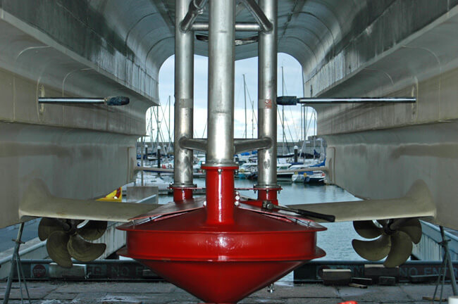
High speed props, hydrofoil stabilising rams and the asymmetric hull combine to create a highly technical craft. Photo Gillian Mills/Inshore Ireland
The vessel is named after the late Ray Keary of the Geological Survey of Ireland who for years had quietly championed the value of Ireland’s marine resource. Finally his message was heard when the GSI received approval from government in 1999 to commence mapping Ireland’s seabed territory, an area that is nine times the size of its landmass.
The 15m vessel will survey inshore waters as part of the INFOMAR project. Until this time the GSI’s project partners at the Marine Institute employed their own research vessels, Celtic Explorer and Celtic Voyager to survey Ireland’s near shore territorial waters. The deep waters were originally surveyed under contract to the GSI by a private company. RV Keary will be more effective in very shallow waters due to increased swath width made possible by her shallow 1.7m draft.
The tendering process culminated in a contract being awarded through IMAR Survey Ltd to Veecraft Marine in Cape Town who laid the keel in November 2007.
Central pod feature
“A lot of thought went into the design,” explains Sean Cullen of INFOMAR. “The main feature is the central pod that houses the multi-beam echo sounder; single beam echo sounder; CHIRP sub-bottom profiler; ultra short baseline underwater positioning system (USBL) and ancillary surveying equipment.
“Housing all the equipment in one location allows for quicker deployment and retraction for maintenance and protection of the equipment. This is a pretty novel approach and despite some early teething problems we are confident that the concept will prove beneficial,” he says.
Stability consideration
A multi-hull was chosen to provide greater stability when surveying. The vessel size has been shown to provide a safe, ergonomical accommodation to crews who will spend some considerable time onboard.
“When running up and down the line, we will be cruising at between 5 and 10 knots; therefore the catamaran will offer a more manoeuvrable platform. When we’re packed up and heading for the shore, however, at full throttle Keary can pick up to 24 knots within a few seconds.
“Two 500HP Cummins with trolling gear boxes give Keary this full variation of the power required for a variety of missions. In addition there is a hydrofoil or fixed wing between the hulls which puts the vessel onto a plane at 16 knots allowing for greater fuel efficiency.”
Survey opportunities
The Keary will also carry out other survey tasks afforded by an array of other equipment that include: dedicated side scan sonar; ‘Sparker’ towed seismic system; A-frame and freefall winch for sampling and a mini ROV (remotely operated vehicle with video).
The aft working deck can also be used for larger ROVs and sampling equipment, aided by a small hydraulic knuckle crane that can also launch the 4.5m RIB.
The bridge is well appointed with radar, automatic identification system (AIS); forward looking sonar; auto pilot; Navtex /Weatherfax; CCTV and electronic engine controls. Being a survey vessel, the depth, positioning data and weather information are of exceptional quality and are interfaced through NMEA from the survey acquisition to the bridge systems.
The survey data is stored onboard in a 14 Terrabyte RAID computer system after processing through dedicated acquisition systems. When fully operational, the team expects to be able to update their website every two weeks once the data has been processed and quality controlled.
Free data
“All our data is freely available to anybody who wants it. This has been a governing principle of our work almost since the beginning of the entire seabed mapping programme. The main users would be fishermen, exploration and aggregate companies, renewable energy stakeholders (i.e. wind and wave energy) and many others. All the data is also given over to the UKHO for updating their Admiralty navigation charts,” Cullen explains.
The INFOMAR team are looking forward to commencing survey in the Spring, starting in Dublin Bay and then progressing around the entire Irish coastline.
“We’re very pleased with the workmanship that Veecraft Marine has put into the vessel and will showcase Keary to them in real-time when they visit Ireland in late June. In the meantime we look forward to the commissioning the vessel in due course and to commence survey work in Dublin Bay and beyond,” he said.