

Seabed mapping data now returning value-added projects to the State
& Gery Flynn
Opening the 2011 annual INFOMAR (Integrated Mapping for the Sustainable Development of Ireland’s Marine Resource) conference, Michael Manley, assistant secretary DCENR and chair of INFOMAR’s Board reminded delegates that its predecessor programme, INSS (to 2005), had delivered a “national asset” that provided Ireland with a data set to underpin economic, environmental, infrastructural, social and policy issues.
“There remains now a crucially important body of work to follow, to map commercially valuable inshore and other waters outside the scope of that achieved by the INSS,” Manley said.

Upland trout: small and aggressive
Brendan Connolly
Ireland’s countryside can roughly be divided into fertile alkaline lowlands and poor acidic uplands. The rivers and lakes of these two contrasting landscapes are also either alkaline,and rich in nutrients, or acidic and nutrient poor. The heather and gorse-covered hills of the west of Ireland are not fertile but they are very scenic, with glittering lakes and rivers adding an exotic sparkle to this rugged landscape.
An upland trout; small but mature
Walking on blanket bog, one can cross the brow of a hill and suddenly look down on a quiet lake, cradled between rough hillsides, wild and unaffected by modern development. These small lakes appear so untouched you feel as if you have just made a discovery. Their dark surfaces exude a calm that seems to have been undisturbed since the last Ice Age.

New marine maps show the way for Ireland’s underwater economy
John Joyce, Marine Institute
Exciting new developments in Ireland’s capacity to uncover its past and explore its future economic potential were revealed last month at a seminar on underwater mapping at the Marine Institute in Galway.
Speakers at this annual seminar of the INFOMAR (INtegrated Mapping FOr the Sustainable development of Ireland’s MARine Resource) programme discussed the discovery of new and historic underwater wreck sites; the application of seabed mapping in the selection of sites for generating wave energy; the protection of fish spawning grounds, and the planning of fish farm sites.

Despite the potential of poor weather, November beach casting can be very rewarding
Brendan Connolly
Angling in Ireland is a year-round sport. Every season has its highlights on lake, river, or sea. In autumn the trout and salmon season is closed, and with colder weather driving coarse fish into deeper water, it is time to take out the beach casting rod and head for the shoreline.
Rods fishing the surf. Photo Brendan Connolly
Irish beaches offer fishing all year; however autumn can be particularly good. Codling on the east coast; bass on the south coast and turbot along the north and west coasts whet the angler’s appetite with flounder being the old reliable. Other species caught by beach casting include ray, plaice, dabs, dogfish, and pollack closer to rocks.

Warships, U-Boats and Liners: A guide to shipwrecks mapped in Irish waters
Tim Magennis
Of the 700 U-boats sunk during WWII it is estimated that approximately 60 were lost in the waters surrounding Ireland. 116 subs that survived the war ended up there too.
One of the many stunning photographs shows the mass of surrendered craft that were herded into Lough Foyle prior to being towed out between November 1945 and February 1946 to the Northern Approaches ̵ 120 miles northwest of the Donegal coast ̵ and put to the bottom. In total, between 30,000 ̵ 40,000 mainly young German submariners gave their lives.
By its very nature, the work being done in coastal and ocean surveying in general in Ireland does not lend itself to easy or accurate translation for the understanding of the public at large. It can be technical and not easily translated into readily understood language. This is unfortunate because in its short life – a mere 12 years – it has been acclaimed by people who know what they are talking about [that the project is] the finest of its type currently being undertaken anywhere in the world.
 https://oceanfocus.ie/wp-content/uploads/2020/05/Ocean_Focus_marine_Publication.png
0
0
Guest Writer
https://oceanfocus.ie/wp-content/uploads/2020/05/Ocean_Focus_marine_Publication.png
Guest Writer2011-11-29 15:03:492019-02-14 08:58:35News from Bere Island
https://oceanfocus.ie/wp-content/uploads/2020/05/Ocean_Focus_marine_Publication.png
0
0
Guest Writer
https://oceanfocus.ie/wp-content/uploads/2020/05/Ocean_Focus_marine_Publication.png
Guest Writer2011-11-29 15:01:292018-08-29 13:36:10Grant-aid committed to light up piers on Donegal islands
https://oceanfocus.ie/wp-content/uploads/2020/05/Ocean_Focus_marine_Publication.png
0
0
Guest Writer
https://oceanfocus.ie/wp-content/uploads/2020/05/Ocean_Focus_marine_Publication.png
Guest Writer2011-11-29 15:03:492019-02-14 08:58:35News from Bere Island
https://oceanfocus.ie/wp-content/uploads/2020/05/Ocean_Focus_marine_Publication.png
0
0
Guest Writer
https://oceanfocus.ie/wp-content/uploads/2020/05/Ocean_Focus_marine_Publication.png
Guest Writer2011-11-29 15:01:292018-08-29 13:36:10Grant-aid committed to light up piers on Donegal islands https://oceanfocus.ie/wp-content/uploads/2011/11/7.5culture_longboat.jpg
507
650
Guest Writer
https://oceanfocus.ie/wp-content/uploads/2020/05/Ocean_Focus_marine_Publication.png
Guest Writer2011-11-23 16:47:152019-02-14 08:59:14Recreating history that goes back over a Millennium
https://oceanfocus.ie/wp-content/uploads/2011/11/7.5culture_longboat.jpg
507
650
Guest Writer
https://oceanfocus.ie/wp-content/uploads/2020/05/Ocean_Focus_marine_Publication.png
Guest Writer2011-11-23 16:47:152019-02-14 08:59:14Recreating history that goes back over a MillenniumRefurbishment of 19th century weir will improve stock monitoring on premier salmon river
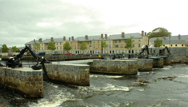
New salmon weir showing refurbished stonework and hydraulic debris lifting systems. Photo IFI
Shane O’Reilly, IFI
On September 2nd last, Inland Fisheries Ireland (IFI) welcomed An Taoiseach, Enda Kenny to Ballina to perform the official opening of the newly refurbished salmon weir, which has stood at the mouth of the River Moy for over 300 years.
Mr Kenny was given a tour of the weir during which he was shown the significant structural and technological improvements that have made it more durable and which will improve IFI’s ability to monitor salmon stocks entering the River Moy system.